
Click the caption to display a printable PDF file. An interactive Google Map is also available.
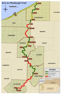


Open sections of the trail (green) are ihttps://freewheelingeasy.com/google-map/mproved and passable. Closed/Proposed sections of the trail (red) are not open to the public, may be unimproved and not passable. Contact the individual trail group or their website for the status of the closed sections.
An interactive Google Map is available.
Links should open in new pages so that people don’t have to navigate back.
One other comment – I really like the link to “Free Wheeling!”
I like that the maps are printable.
The trail segment between OCSP and McClintock Trail (the lower 3 miles in OCSP) is currently marked as share-the-road. I know it is not a good route for all levels, but because it is marked as share-the-road, do we want to include it on the map?
The brief descriptions of the individual trails are very nice, although it may get a bit crowded once all the descriptions are added. Could you possibly move the descriptions away from the map and have an arrow connecting the description to the trail segment? Just a thought